
Studio Projects
Highlights from CRP Studios
Planning and design studios are fundamental for the CRP department mission and both the undergraduate and graduate curriculae. As the best vehicle for Cal Poly's learn-by-doing pedagogy, the studio experience allows students to engage in quasi-real projects and work with real cities and their officials, stakeholders and communities, helping them to become better prepared for professional life.
2023-2024
Undergraduate (Junior Year): CRP 341 Urban Design Studio III (Spring 2023). Instructors Ryan Sandwick and Beate von Bischopinck.
Client: City of Morro Bay
Students Develop Downtown District Plan in Morro Bay
While students in the City and Regional Planning program are no stranger to policy review and technical analysis, design principles and placemaking can present a more abstract challenge. The Urban Design Studio for third year undergraduates (CRP 341) aims to bridge this gap, challenging students to combine technical expertise with the often ambiguous
and dynamic art of placemaking. Co-led by Prof. Ryan Sandwick and Dr. Beate von Bischopinck, the focus of the studio was on Morro Bay. Tasked with designing a downtown district plan, students worked to link the waterfront Embarcadero to downtown, while addressing workforce housing and creating a distinct sense of place.
“This studio is about pushing students out of their comfort zone,” said Prof. Sandwick. “They tend to thrive in technical and policy-driven solutions, but when it comes to materiality and scale—the design elements of placemaking—there’s often a gap. “
Read the full article in our FOCUS 21 Journal.

CRP 341: Student Mitchell Moore engages with a Morro Bay resident at an outreach event.
Undergraduate (Senior Year): CRP 410/411 Community Planning Lab I & II (Fall 2023/Winter 2024).
Instructors: Dave Amos and Kelly Main.
Client: City of Palo Alto
Bold Plan for More Housing in a Palo Alto Industrial District
The city of Palo Alto, California might be best known for Stanford University and it’s central location in Silicon Valley. But, increasingly, it’s known for high housing prices and low available housing supply. The City adopted a draft Housing Element, a plan to identify new areas for housing development, but it was twice rejcted by the State of California’s
Department of Housing and Community Development for not going far enough to meet the area’s allocated housing goals. The city needed a bold strategy to find more space within its city limits to rezone for homes. They found X acres of low-density industrial uses near the border of Mountain View along San Antonio Road that would provide space for 1,200
new housing units, putting a major dent in their housing needs. Palo Alto teamed up with Cal Poly’s Community Planning Studio (CRP 410/411) to envision what this new mixed-use neighborhood could look like.
The students began their process with a site visit to walk the corridor with planning staff and gather information about the site. Students noticed that the site consisted primarily of low-density industrial uses, auto shops, machine shops, and gas stations. There were areas of residential uses on the south end of the corridor. The area also included community and cultural uses such as The Foster Museum, Hatemi Mosque, and Taube Koret Campus for Jewish Life. The corridor is also home to an important historic site: Fairchild Semiconductor
Corporation invented the first commercially-produced integrated circuit on Charleston Road just off of San Antonio Road. This invention kickstarted the computer industry and Silicon Valley.
Read the full article in our FOCUS 21 Journal.

CRP 410/411: The proposed site plan includes new greenspaces, mixed-use development, and a redesigned San Antonio Road.
Graduate (Second Year): CRP 552/554 City and Regional Planning Lab (Fall 2023 & Winter 2024).
Instructor: Michael Boswell.
Client: City of Morro Bay.
A Climate Action Plan for Morro Bay's Unique Challenges
In Fall of 2023, the second-year cohort of the MCRP program embarked on a two-quarter studio project under the guidance of Dr. Mike Boswell. Their objective was to design a comprehensive Climate Action Plan (CAP) tailored to meet the City of Morro Bay’s unique
climate challenges and coastal context. Over several months, the students conducted extensive research, engaged in public outreach, and collaborated on complex problem-solving to develop a CAP that sets Morro Bay on a path toward greater sustainability and resilience.
Read the full article in our FOCUS 21 Journal.

CRP 552/554: A tabling event gave students a chance to solicit feedback on existing conditions.
Graduate (First Year): CRP 553 Project Planning Lab (Spring 2023).
Instructor: Hemalata Dandekar.
Client: City of Paso Robles.
MCRP Students Create Two Proposals for Paso Robles Greenfield Site
In Spring 2024, first-year students of the MCRP program embarked on a transformative design studio in partnership with the City of Paso Robles. Students were tasked with creating a conceptual development plan for North Chandler Ranch, an undeveloped greenfield site with the potential to meet the city’s future housing and commercial needs.
Over the course of nine weeks, the students engaged in community interviews, geographic analysis, 3D modeling, and consultations with local experts to craft plans which reflected both the needs of the community and unique features of the site. Their efforts culminated in two distinct design proposals, each focused on providing diverse housing options,
expanding green spaces, and developing commercial corridors all while preserving the natural beauty of the area.
Read the full article in our FOCUS 21 Journal.

CRP 553: Students present their designs to the Paso Robles Planning Commission.
2022-2023
Undergraduate (Sophomore Year): CRP 203 Urban Design Studio II (Spring 2023).
Instructors: Beate von Bischopinck and Thando Mthembo.
Design Development of the CalTrans Site, San Luis Obispo, CA
The students worked on two combined sites at the corners of Madonna and South Higuera roads, bordered by San Luis Creek and Highway 101. Formerly, this 15-acre area was part of Japan Town and it is presently occupied by CalTrans facilities who has plans to vacate it in the future. Due to its location, the area has great potential for redevelopment as a gateway to SLO. An existing historic building located on the site at South Higuera had to be preserved and reused, and the influence of adjacent ETO Park, a small existing neighborhood, and the place history had to be considered.
Working in small teams, the students assessed existing conditions including the impact of SLO's general plan, the Mid Higuera Enhancement Plan, and zoning regulations before
studying planning precedents and moving to conceptual development and visioning. The teams came up with creative redevelopment proposals combining tourist amenities, housing, and commercial uses. Design ideas were captured through a mix of analog and digital tools to represent site plans, sections, land use diagrams, and pedestrian and bird's eye views. A final portfolio and a poster concluded each team’s work.

CRP 203: Final poster by Briana Medvecki, Jennifer Hugoo and Emileo Padilla Chavez.
Undergraduate (Junior Year): CRP 341 Urban Design Studio III (Spring 2023). Instructors Amir Hajrasouliha, Beate von Bischopinck and Thando Mthembu.
Client: Monterey Resident Mr. Wallace Gordon
Downtown Revision Plan, Monterey, CA.
Responding to a request from Mr. Wallace Gordon (Cal Poly Alum, member of the CAED's Advisory Board, and Monterey resident), this studio engaged in developing an urban design vision for Monterey's downtown that could ensure it is a welcoming place for residents and tourists alike. Due to their location and potential, the class identified ten specific sites for further studies and concept development, and a comprehensive transportation plan was proposed for the area.
The students and instructors spend two days in Monterey exploring the city and meeting with Community Development Director Kimberley Cole, her staff, and groups of stakeholders. Important information was provided by Mr. Gordon with his profound knowledge of the city and its history. The students studied and mapped existing conditions, procured applicable precedents, and developed urban design visions and a transportation
proposals. Over the board and digital tools were utilized to develop the final proposals, including ArcGIS City-Engine for three-dimensional modeling. The combined work resulted in a document that will help Monterey implement a new vision for its downtown.

CRP 341: Visioning and concept for Monterey's Downtown. Place to Live Map: enhancing livability for residents.
Graduate (First Year): CRP 553 Project Planning Lab (Spring 2023).
Instructor: Hemalata Dandekar.
Client: City of Atascadero Planning Department.
Atascadero Downtown Conceptual Design Plan. An urban design-focused plan for Atascadero City’s historical core, included the iconic City Hall and Sunken Gardens and projected a 30-year horizon for four interlinked zones. Each offered unique thematic contributions and services for residents and visitors to the City of Atascadero as follows:
1. Colony Gardens: mixed-use commercial development enhanced pedestrian connections between the Sunken Gardens, Colony Square, and El Camino Real.
2. Gateway District: historic revitalization and promotion of the arts offered venues for family-centric community events.
3. Old Town at the core of Atascadero: affordable space for a small-business-incubator and a variety of shops, restaurants, and public spaces integrated with pedestrian only pathways.
4. The Printery District: abandoned and underutilized spaces were repurposed to create community-oriented services, affordable housing options, and pedestrian greenways that
improved connectivity to the periphery of the city core.
The four zones were woven together through design elements that included mixed-use developments which were interconnected with a pedestrian network to improve walkability and expand greenery and shade coverage. This concept plan for Atascadero brings life back into Atascadero’s city core through a resident-focused design plan that differentiates the city so as to also appeal to visitors.

CRP 553: Vision for Old Town Atascadero as small business incubator with a variety of shops, restaurants, and pedestrian plazas and paseos.
Graduate (Second Year): CRP 552/554 City and Regional Planning Lab (Fall 2022 & Winter 2023).
Instructor Dave Amos.
Client: City of Desert Springs.
Downtown Concept Plan, City of Desert Springs, CA.
Students in this graduate planning studio completed a Downtown Concept Plan for the City of Desert Hot Springs, California. The plan includes strategies the City can use to revitalize a flagging downtown and differentiate itself from nearby cities like Palm Springs. Students researched policies to reduce storefront vacancies, increase shade for the extremely hot environment, rezone land for more commercial uses, and improve pedestrian and bicycle facilities.
The studio ran from September 2022 to March 2023 and in that time the graduate students visited Desert Hot Springs twice to solicit public input for the plan. Students tabled at local stores to understand the existing conditions. They then held a visioning workshop to chart a vision for downtown in collaboration with participants. The students also conducted online outreach through a website, survey, and Zoom town hall.
The City’s reaction to the completed Concept Plan was positive and the results were shared with the City Council. The City hopes to use the plan as a foundation for their efforts to
improve downtown.

CRP 552/554: Students holding a work meeting with community members in Desert Springs.
2021-2022
Undergraduate (Sophomore Year): CRP 203 Urban Design Studio II (Spring 2022).
Instructors: Beate von Bischopinck and Amir Hajrasouliha.
Missing Middle Housing, San Luis Obispo, CA.
The studio worked on a 3.3-acre site in the tourist district of the City of San Luis Obispo. Situated along Monterey Street, this location has excellent potential to be redeveloped as a mixed-use residential and commercial district. Students addressed the city's housing needs by providing "missing middle housing" options in an area zoned for tourist uses. Students proposed creative proposals by combing uses and activities that support hospitality and tourist uses with residential units. Students in teams of three start their project with a site assessment and studying the existing zoning regulations. Next, the teams used lessons learned from their case studies to develop their conceptual designs. The teams' design ideas came to life with development plans, including site plans, sections, elevations, and perspectives. Deliveries were completed using a mix of hand and technical drawing, AutoCAD, SketchUp, and Photoshop.

CRP 203: Site plan and section drawings from the project by Madeline Hines, Jenny Nguyen and Yvonne Huynh.
Undergraduate (Junior Year): CRP 341 Urban Design Studio III (Spring 2022). Instructors Amir Hajrasouliha and Beate von Bischopinck. Client: City of Campbell Planning Department
Concepts for the Winchester Light Rail Station Area, CA.
Recognizing several housing opportunity sites as identified in the City of Campbell's Plan for Housing (2023-2031), this studio contributed to the City's long-range planning efforts, the Valley Transit Authority (VTA), and the County Office of Supportive Housing (OSH) through the development urban design concepts for the area around the Winchester light rail station.
The studio's eight student teams came up with alternative long-range visions featuring conceptual development scenarios for both public and private lands that included land uses, building envelopes, public facilities, circulation, and open spaces. The work was conducted in three major phases: a) assessment of community needs, the area's potential, and current policies and initiatives; b) visioning, and c) development of urban design concept proposals. Although the students prepared their proposals following the city's land use regulations and existing guidelines, they also suggested alternatives for parking standards along TOD development principles in order to create multimodal, pedestrian-friendly projects. Students presented their final proposals to the planning commission in a public session.
The CRP 341 Studio is indebted to Brian Leventhal (Campbell's City Manager), Rob Eastwood (Community Development Director), Stephen Rose (Senior Planner and Housing Coordinator), Daniel Farna (Senior Planner), and Larissa Lomen (Assistant Planner), for generously making time to arrange the field trip and responding to the student work. Josselyn Hazen, Transit-Oriented Development Project Manager at VTA, and Jessie O'Malley Solis, TOD Manager at VTA, attended a virtual session with the student teams to comment on their concepts. During the class site visit, Council member Liz Gibbons and Susan Blake, chair of the Capbell historic preservation committee, explained the most significant challenges and opportunities in Campbell and for our site. Council member Susan M. Landry provided the students with valuable written comments.

CRP 341: Site plan and partial view of one of the proposals for Campbell's Winchester Light Rail Station Area. Student team: Aidan Clark, Eric Wang, Peyton Victoria and Sharon Ng.

Undergraduate (Senior Year): CRP 410/411 Community Planning Lab (Fall 2021 & Winter 2022). Instructor Dave Amos. Client: County of Los Angeles.
Trails and Rural Character Vision Plan, Town of Acton.
Involving 22 CRP senior students, this was a comprehensive planning studio in cooperation with the County of Los Angeles. The focus was the unincorporated community of Acton, located in the Antelope Valley, between Palmdale and Santa Clarita. With only 7,500 residents in a rural setting, the community was not interested in increasing density or adding urban infrastructure but hoped the students could help them communicate to the County their preference for preserving their rural character.
The class completed a Trails and Rural Character Vision Plan, incuding a detailed Existing Conditions Report and policies for the preservation of the rural character. As many residents own horses and equestrian recreation is popular, the students held a community workshop for a collaborative mapping exercise identifying key equestrian trails. Many of these trails were informal and residents prioritized them to get the County to own and maintain them. The class also recommended that Acton lobby the County for additional policy changes to preserve their rural lifestyle. For instance, as residents opposed urban infrastructure such like streetlights, a Night Sky Ordinance restricting the amount and kind of outdoor lighting was proposed to preserve views of the night sky. Other policy recommendations included design guidelines for new development, involving Acton's Town Council earlier in the project review process, and reducing cut-through traffic from commuters.

CRP 410/411: Cover page of Acton's Trails and Rural Character Vision Plan.
Undergraduate (Senior Year): CRP 410/411 Community Planning Lab (Fall 2021 & Winter 2022). Instructor Cornelius Nuworsoo. Client: Tulare County.
Springville Community Plan.
This studio included 19 undergraduates working on a comprehensive draft update to the Springville Community Plan in Tulare County. The greater Springville Planning Area is a sprawling, rural residential community spread across 26 square miles in the Foothills of the Sierra Nevada Mountains and serves as an entry to the Sequoia National Park. The study area had a population of approximately 2,850 residents and 2,090 housing units in 2020. The usual field activities like a land use inventory and four community meetings took place in-person with participants in face coverings.
The 2040 Plan update sought to accommodate population increase and minimize negative impacts of growth by striking a balance between preserving agricultural lands while meeting other land-use needs, establishing a program for energy conservation and efficiency, adopting green building and water conservation practices, and reducing greenhouse gas emissions. Like previous years, there was a formal agreement with Tulare County, the client, which required professional conduct from project participants while the students benefited from the experiential learning opportunity in preparing a plan for a real community. Tulare County is looking to include the product of the work effort in its County General Plan.

CRP 410/411:Map with the preferred alternative proposed land uses; Springville Community Plan Update.
Graduate (First Year): CRP 553 Project Planning Lab (Spring 2022). Instructor: Hemalata Dandekar. Client: City of Campbell Planning Department.
Downtown Campbell Vision Plan.
The City of Campbell is noted for its attractive historic downtown which attracts residents and visitors to its many restaurants, bars and popular weekly Farmer's Market. Looking to the future, Campbell's planning department tasked students with: enhancing the connectivity of the light rail station to the historic downtown; envision strategic densification of mixed use, workforce and affordable housing development; enhance walkability with parklets, reimagined circulation and wayfinding. The studio developed the Downtown Campbell Vision Plan that included three zones:
1: The Civic Commons that create a distinctive core destination with a redesigned Civic Center and a Central Avenue promenade leading to the VTA station with public amenities and historic character.
2: The Branching Out of the Downtown extending downtown east to the Community Center and west to the Pruneyard shopping complex, increasing density and adding a business-servicing public plaza and garden.
3. The Orchard that prioritizes business diversity, affordable housing, outdoor spaces, public art, and a pedestrian-friendly linkage from the downtown to open recreation space fronting Los Gatos Creek.

CRP 553: Concept5 for mixed-use development and wider sidewalks along East Campbell Avenue.
Graduate (Second Year): CRP 552/554 City and Regional Planning Lab (Fall 2021 & Winter 2022). Instructor Kelly Main. Client: Oceano Economic Development Council.
Oceano Action Plan.
Retained by Oceano's Economic Development Council (OECD), the thirteen students in this graduate studio developed an Action Plan for this unincorporated community of approximately 7,000 in San Luis Obispo County. The OECD is a local organization devoted to the revitalization of Oceano, while still preserving its cultural character and historic heritage. Nick Alter, Chair of the OEDC, along with a Project Advisory Committee created for the studio, provided support and guidance regarding community issues and concerns.
A key effort in developing the Oceano Action Plan were the community engagement efforts that maximized a culturally diverse community participation process and included a survey representative of residents' opinions. Outreach efforts included interviews, focus group meetings and a survey that included land-use preferences. Surveys and interviews were conducted online and in person (door-to-door and at public sites, such as grocery stores, shops, and restaurants), a challenging task given continuing concerns about COVID-19 and associated approaches to health and safety.
The focus of the community engagement process was the completion of a dor-to-door survey, conducted in both English and Spanish. A sampling method of neighborhood blocks was utilized to ensure the survey results were representative of residents' opinions (95% confidence interval/six-point margin of error). The 275 surveys were gathered by the students and by seven Spanish-speaking Cal Poly students, four of whom also from CRP. The survey was made possible by a grant from the Errett Fisher Foundation. Survey results and a description of the methodology used by the studio are available from the Oceano Economic Development Council (https://oceanoedc.org/).
Subjects covered in the Oceano Action Plan address land use preferences, with a focus on several key areas such as Pier Avenue, circulation, public/park spaces, health, equity, sustainability (economic, environmental, social, and cultural), and safety. Funding sources for strategies/actions are also considered.

CRP 552/554: The class in front of the Oceano Train Depot.
2020-2021
Undergraduate (Sophomore Year): CRP 202 Urban Design Studio I (Winter 2021).
Instructors: Beate von Bischopinck and Josh Cross.
Monterey Street Corridor Redevelopment, San Luis Obispo, CA.
The pandemic had all CRP classes taught remotely with Zoom as a meeting space. In-person visits and analysis were replaced by online research and Google Earth and Street View tours, and our studio used Concept Board, a virtual platform for collaborative design work and critiques. Our project area was the Monterey Street corridor in San Luis Obispo, between the train tracks and Johnson Street. A natural corridor for the expansion of the downtown, currently consists mainly of one-story commercial buildings with front parking or large front setbacks. The students explored urban design scenarios for a denser and mixed-use development, as well as opportunities such as connecting to a new bike path along the train tracks, the possibility for a future light train stop using the existing railroad infrastructure, and adapting the existing railroad bridge into a gateway into Downtown SLO.

CRP 202: Monterey Corridor Redevelopment; by Clark, Partain, Yamamoto & Hauk.
Undergraduate (Sophomore Year): CRP 203 Urban Design Studio II (Spring 2021). Instructors:Amir Hajrasouliha and Beate von Bischopinck.
First Street Corridor, City of Gilroy, CA
The studio worked on the City of Gilroy's First Street Corridor, as did the Urban Design Studio III (CRP 341). Collectively, the students conducted background research, site analysis, literature review, reported on case studies for inspiration, and identified a set of design principles to apply in design development. For the design phase, the class was divided in two groups: one adopted a vision with a focus on increasing the residential uses, while the other focused on intensifying commercial uses and a higher density. Students were then divided in teams of 3 or 4 to develop urban design proposals for specific sections along the corridor. Their sections were smaller than those taken by students in the CRP 341 studio, but their design products were more detailed. Deliveries (site plan, sections, elevations, and perspectives) were completed using a mix of hand and technical drawing, AutoCad, SketchUp and Photoshop.

CRP 203: First Street Plaza, City of Gilroy. Design by Niklas Nordstrom.
Undergraduate (Junior Year): CRP 341 Urban Design Studio III (Spring 2021). Instructors Amir Hajrasouliha and Beate von Bischopinck. Client: City of Gilroy Planning Department.
First Street Corridor Long-Term Development Concept, Gilroy, CA.
This studio's mission was to conceptualize long-term development alternatives for the First Street Corridor, in the City of Gilroy, California. The corridor was re-imagined as a mixed-use district, up-zoned from its current use of strip malls and parking lots. Due to the COVID-19 pandemic, the studio had to operate in an online format, with both asynchronous and synchronous meetings in Zoom. Although the lack of site visits and public engagement was a sever limitation, the students were able to explore new technologies and various web-based programs to generate a useful document for Gilroy.
Starting from an analysis of the area and the conditions set by the existing zoning regulations, the class worked on four alternative development scenarios. ESRI's ArcGIS was used to study existing conditions and ArcGIS Urban and CityEngine were used for scenario planning. Different alternatives for the Corridor, with demographic and environmental capacity changes in real-time, were developed accompanied by 3D modeling to depict the resulting urban environments. Each of the four scenarios for the First Street Corridor focused on a unique theme and density. The final proposals, presented to Gilroy's planning department in ArcGIS StoryMap, Powerpoint, and inDesign, will enable the City to start a dialogue with the public, collect opinions about the corridor's future, and inform their efforts to adapt the existing zoning regulations.

CRP 341: First Street Corridor Urban Design Vision, City of Gilroy. Above: Section perspective of Scenario C. Below: Bird's eye view of Scenario A.

Undergraduate (Senior Year): CRP 410/411 Community Planning Lab (Fall 2020 & Winter 2021). Instructor Dave Amos. Client: City of San Luis Obispo Planning Department.
The Missing Middle Housing Report, City of San Luis Obispo.
Students in this studio developed a comprehensive housing report for the City of San Luis Obispo dealing with the "Missing Middle": low-rise, medium-density housing, such as duplexes, triplexes, fourplexes, townhomes, ADUs, and cottage courts. Missing middle housing, when added to single-family residential areas (e.g., the suburbs), can expand housing choice, provide more affordable options, and increase overall density. During this COVID year, students met via Zoom and conducted a limited number of public outreach activities, including stakeholder interviews and an online public survey. The final report proposed changes to the City's zoning code to increase residential density and increase active transportation trips. The City of San Luis Obispo will use the report to help guide its efforts to its missing middle housing strategy.

CRP 410/411:Cover of Housing report for the City of San Luis Obispo.
Undergraduate (Senior Year): CRP 410/411 Community Planning Lab (Fall 2020 & Winter 2021). Instructor Cornelius Nuworsoo. Client: City of San Joaquin.
San Joaquin Community Plan Draft Update.
Following the department's emphasis on hands-on learning in a virtual mode due to the COVID-19 pandemic,with unwavering determination, this studio's group of 20 undergraduate senior worked on a comprehensive draft update to the General Plan for the City of San Joaquin in Fresno County. Ususal field activities, such as land use inventory and community meetings, were conducted virtually.
The 2040 Plan update sought to accommodate population increase and minimize the negative impacts of growth by striking a balance between preserving agricultural lands while meeting other land-use needs, establishing a program for energy conservation and efficiency, adopting green building and water conservation practices as well as new landscape standards, and reducing greenhouse gas emissions. Although there was no formal agreement with the city, the students benefited from the experiential learning in preparing a plan for a real city.

CRP 410/411:Proposed zoning map, City of San Joaquin Community Plan Update.
Graduate (First Year): CRP 553 Project Planning Lab (Spring 2021). Instructor: Hemalata Dandekar. Client: City of Gilroy Planning Department.
Downtown Concept Plan, Gilroy, CA.
This studio contributed to the City of Gilroy's efforts to update the Downtown Specific Plan with a strategic focus on the core blocks of the historic downtown centered around "Gourmet Alley." The residential area, between downtown and Highway 101 was considered to increase economic development and minimize displacement of lower-income residents. The three project phases were: a) assessment of community needs and assets; b) case studies, visioning, and goals setting, c) development of strategies and recommendations. Student teams developed plans to: 1)d Connect Gilroy and encourage visits to Gilroy's Downtown with way-finding initiatives, enhanced streetscape and a pedestrian-orientation; 2) Develop a green way connecting the civic center with East Gilroy building on physical assets in the area and introducing new recreation community and senior center, 3) Preserve and promote Gilroy's historic buildings and spaces, adding paseos, a public square and enhanced gateways; and 4) Develop Gourmet Alley with mixed-use infill buildings which complement the historical character of the downtown with arcades, outdoor seating, decorative pathways and signage at entry points.

CRP 553: Illustrations from the
Concept Plan for Downtown, Gilroy.


Graduate (Second Year): CRP 552/554 City and Regional Planning Lab (Fall 2020 & Winter 2021). Instructor Kelly Main. Client: City of Norwalk.
Norwalk Strategic Plan.
In 2020, the City of Norwalk retained the second-year graduate class to create a Strategic Plan. Richard Rojas, Norwlak's Deputy City Manager and a graduate of Cal Poly's MCRP Program, proposed the project and, along with City's planning staff and that of many other departments (Sheriff's, Social Services, Public Services, Recreation and Parks), provided support and guidance. Over a 20-week period, the students engaged with community stakeholders to develop a document aimed at increasing public health and equity for all Norwalk residents. The project team was inspired by other communities that are integrating environmental justice and equitable development approaches into plans while working towards healthy, inclusive neighborhoods. The team sought to bring these innovative planning practices to the City of Norwalk.
During a challenging year for many communities, including Norwalk, and with the studio online and unable to visit Norwalk, the students were determined to ensure a diversity of community members were able to participate. Community engagement methods included the creation of the Norwalk Connected website, social media postings on Facebook and Instagram, distribution of online and paper surveys, an online interactive mapping exercise, interviews with community members, and focus group engagement. Whenever possible, these methods were provided in a billingual or multilingual format (English, Spanish, Lorean, and/or Tagalog). Over the course of approximately three months, the team estimates that more than 500 Norwalk residents participated in at least one of our outreach efforts, contributing immensely to the class efforts in creating the Norwalk Strategic Plan.

CRP 552/554: Map of the retail walkshed in Norwalk.

Undergraduate (Sophomore Year): CRP 202 Urban Design Studio I (Winter 2020).
Instructors: Amir Hajrasouliha and Beate von Bischopinck.
Mixed-Use Development in San Luis Obispo, CA.
The objective of this studio was to design a mixed-project on a site at the corner of Foothill Boulevard and Chorro Street. They were introduced to the city's approval process for a new student housing project across the street by the developer and the construction manager, studied the city zoning and land-use regulations, conducted a site analysis, collected information from stakeholders, and conducted case studies of similar mixed-use projects in California and elsewhere. Organized in small teams, the students came up their own use full development programs and design proposals that were required to respond to existing conditions and be well integrated to the urban fabric. Through the project, the class was introduced to the full scope of the urban design process; explored methods, elements and principles of good design, and continued to develop their graphic skills in AutoCAD, SketchUp, and Adobe Suite.

CRP 202: Mixed-Use project in San Luis Obispo, by Ariella Stanford & Alan Cazares.
Undergraduate (Sophomore Year): CRP 203 Urban Design Studio II (Spring 2020). Instructors: Vicente del Rio and Beate von Bischopinck.
Redevelopment of Two Blocks in San Luis Obispo, CA.
Due to the COVID-19 epidemic, this studio was totally conducted online. Student teams were asked for redevelopment projects of a 3.7-acre area defined by Higuera, Pacific, Archer, and Pismo Streets in San Luis Obispo, in compliance with the Downtown Concept Plan, the Mid Higuera Enhancement Plan, and parking requirements. After a thorough study of existing documents, the class conducted a site and context analysis (Google Earth, Streetview, and city maps), analyzed similar redevelopments based on the 8 principles from SLO’s Downtown Concept Plan, and delivered their projects through a Powerpoint, a poster, and a professional-level report. Projects responded to the city's vision, local needs and economic opportunities, through sustainable, walkable, and culturally appropriate solutions.

CRP 203: Mixed-Use and Residential Complex in San Luis Obispo, by Abraham Miranda & Alyssa Adams.
Undergraduate (Junior Year): CRP 341 Urban Design Studio III (Spring 2020). Instructors Vicente del Rio and Hemalata Dandekar. Client: County of Santa Clara Planning Department.
Urban Design Visions for San Martin, CA.
Responding to a request from the County of Santa Clara Planning Department, this studio developed long-range urban design visions for the core of San Martin, a small rural community of 7,000 residents. The pressure for new suburban-type housing due to the proximity to the cities of Morgan Hill and Gilroy is great and expected to increase with the arrival of high-speed train and better commuting services to the Bay Area, as well as with new economic opportunities including agricultural tourism and healthy food systems. The ten student teams developed eight urban design proposals for four distinct areas for the San Martin core and two proposals for circulation/wayfinding guidelines for the entire core. The County of Santa Clara will use the final posters, Powerpoints, fly-throughs, and unified report to help initiate a discussion with the community about possible futures. Due to the limitation imposed by the COVID-19 pandemic, this project was fully developed online.

CRP 341: project for South Monterey Highway, San Martin by Vinson Kwan, Henry McKay, Trisha Tran, and Wesley Wong.
Undergraduate (Senior Year): CRP 410/411 Community Planning Lab (Fall 2019 & Winter 2020). Instructor Kelly Main. Client: City of Santa Fe Springs.
Health Element Update, City of Santa Fe Strings General Plan.
This studio was retained by Santa Fe Springs, a city of approximately 18,000 in southeastern Los Angeles County, to create a Health Element for their General Plan. The work process started in the Fall Quarter with an intense investigation of local conditions and community needs, and lead to the development of the element itself in the Winter Quarter.
To ensure the participation of a wide diversity of community members, the class undertook an extensive engagement process which included information and participatory booths at community-wide events and venues, such as the Dia de los Muertos (Day of the Dead) celebration and the Santa Fe Springs Swap Meet. Children and young adults were particularly important for the outreach efforts.
A focus group was held with the City’s Youth Advisory Commit-tee, a survey was carried out at the Santa Fe High School, and participatory activities were held with first through sixth-grad-ers at the local Boys and Girls Club where the Place It! participatory method (created by James Rojas) was used. Through this method, participants used colorful recycled and random objects to draw and built their ideal park while the Cal Poly students interviewed them. Understanding the what, the why, and the ideal allowed the class to develop realistic suggestions for the City’s existing parks.
This lab's engagement process helped the class produce a Health Element tailored to Santa Fe Springs’ needs. Equally important, our students were exposed to a variety of participatory activities, carried out with a great diversity of community members, preparing them to better design and execute outreach efforts in the diverse communities they will serve.

CRP 410/411:Health Element of Santa Fe Springs General Plan.
CRP students in front of the City's High School.
Graduate (First Year): CRP 553 Project Planning Lab (Spring 2020). Instructor: Hemalata Dandekar. Client: County of Santa Clara Planning Department.
Strategic Development Plan for San Martin, CA.
This plan covers 11.6 square miles around the village of San Martin in unincorporated Santa Clara County. Contributing to the county’s long-range planning efforts for the Santa Clara Valley region and the San Martin community, the plan proposes an integrated and cohesive physical, cultural, and socio-economic transformation supportive of local community needs and existing small-scale farming operations; expands niche agriculture, organic farming, and ecology-based tourism; and enhances rural character by design.
The plan includes strategies for: a) Enhancing rural character and a sense of place by updating existing design guidelines and developing a street-hierarchy system to improve connectivity enhance, safety, encourage multimodal use, and reinforce the rural aesthetic; b) Preserving agriculture by promoting a vibrant agricultural economy and preventing the conversion of high-quality agricultural land to non-agriculture uses; c) Initiating agritourism activity with a Farmers Toolkit and A Marketing Plan which promotes San Martin as an agritourism hub; and d) Development Zones and Transect Plans are delineated as land use guiding strategies to facilitate preserving the rural character and agriculture in San Martin and increasing agritourism.

CRP 553: Strategic Development Plan for San Martin, California. Design scenario for rural character along San Martin Avenue.
Graduate (Second Year): CRP 552/554 City and Regional Planning Lab (Fall 2019 & Winter 2020). Instructor Cornelius Nuworsoo. Client: City of McFarland.
City of McFarland General Plan Update.
This studio engaged sixteen graduate students in preparing a comprehensive revision and updating of the City of McFarland's General Plan, originally prepared in 1991. Through a process involving residents and stakeholders, the class formulated a development scenario to accommodate aspirations for growth in population, housing, and jobs by 2040.
Located in Kern County, California’s Central Valley, approximately 5 miles north of Bakersfield, the city covers approximately three square-miles of land consisting of mostly residential, institutional, and agricultural uses. Its Sphere of Influence and the surrounding area are primarily agricultural. California's Highway 99 runs right through the city as the major north-south route. McFarland's population of 13,930 residents (2017) is predominantly Hispanic or Latino (96 percent) with a median household income well below the County and State's median incomes thus qualifying it as a disadvantaged community and triggering the State requirement to add an Environmental Justice Element to the General Plan update.
Comprehensive research on community characteristics, a thorough analysis of opportunities and constraints for development as well as public feedback guided the studio work. The new General Plan includes detailed long-term goals, objectives, polices, and programs to inform future development on fourteen Elements: Land Use; Circulation; Conservation; Housing; Environmental Justice; Economic Development; Public Facilities; Safety; Health; Open Space; Noise; Community Design; Air Quality; and Sustainable Agriculture. The new General Plan can lead McFarland to improve residents' quality of life, provide diverse housing options, generate economic vitality, and enhance its attractability as a strategic stop for travelers along Highway 99.
From the three distinct growth scenarios presented by the class to the City, the preferred alternative includes a variety of changes to land use in designated growth areas to accommodate infill development for housing and commercial growth; redeveloping downtown for mixed-use (see Figure); and targeting highway commercial and industrial uses along Highway 99 within an expansion area of its sphere of influence toward the south of City limits.

CRP 552/554: revitalization concept for downtown, new General Plan for the City of McFarland.

CRP 552/554: Key growth areas and land uses; General Plan for the City of McFarland.
2018-2019
Undergraduate: CRP 202 Urban Design Studio I (Winter 2019).
Instructors: Amir Hajrasouliha and Beate von Bischopinck.
An Urban Design for Collaboration and Innovation at Cal Poly.
The two sections of this studio collaborated in designing the core of Cal Poly campus according to the university long term plan. Students proposed new academic and service buildings with restaurants and coffee shops, and an innovation center at the heart of Cal Poly campus. The common goals of the proposals included encouraging interaction between students of various disciplines and faculty members of the Cal Poly community, creating a walkable and vital campus throughout the day and year, and encouraging outdoor learning and social activities with the help of green roofs, and various types of plazas and open spaces.

CRP 202: project by Liam Cromley and Henry McKay.
Undergraduate: CRP 203 Urban Design Studio II (Spring 2019). Instructors: Vicente del Rio and Beate von Bischopinck.
Gateway Site Development in Paso Robles, CA.
Both sessions in this studio got involved in contributing to the City of Paso Robles Community Development Department by envisioning development alternatives for an 8-acres site located at the corner of Spring and Fourth streets. Currently, the site is a partially occupied low-income apartment complex scheduled for redevelopment in the near future. Based on the site's excellent location and easy access to the downtown, Highway 101 and the Salinas River, the student teams presented several alternatives which included ideas for mixed-use development, affordable apartments, high-density town-homes, and public open spaces.
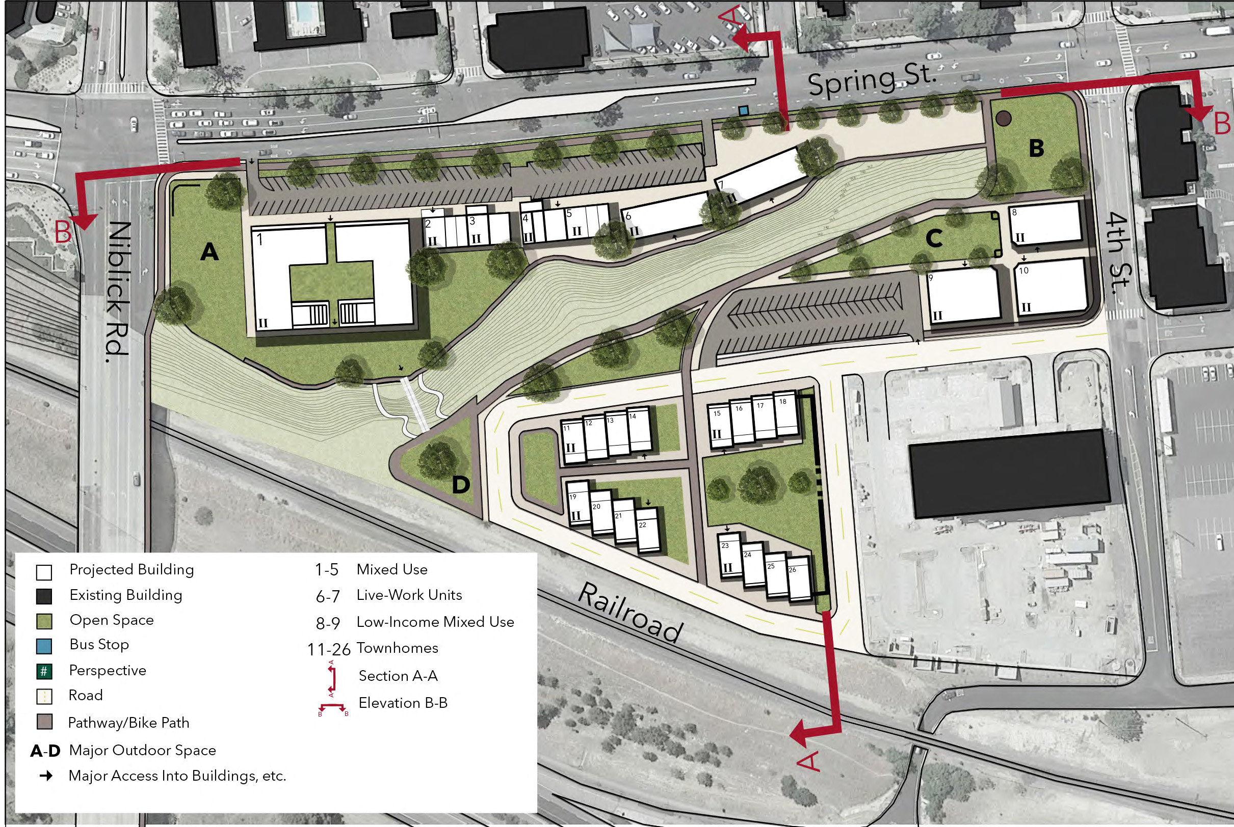
CRP 203: project by Vinson Kwan, Ian Madrigal, Henry McKay & Trisha Tran.
Undergraduate: CRP 341 Urban Design Studio III (Spring 2018). Instructors Vicente del Rio and Hemalata Dandekar. Client: City of Glendora Planning Department.
Rethinking Downtown Glendora, CA
This third-year undergraduate studio contributed to the City of Glendora long-range planning efforts by developing an urban design vision to strengthen the linkage between the Old Village, the future Metro’s Gold Line Light-Rail Station, and Route 66. Although the project area is located in the heart of Glendora, but holds a hodgepodge of underutilized land, commercial and office uses, warehouses, small industries, as well as town homes and single-family residences. It is expected that, when the Metro line and the station are ready they will cause significant impacts on the project area. Divided into nine teams, the students developed different alternative plans, with medium and long scenarios, for public and private development as well as circulation and streetscape concepts. The proposals were present to the planning commission and the city council, and are helping the planning department to educate developers on the possibilities and to help direct public investments.

CRP 341: project by Chris Cortez, Clarissa Flores, Nick Johnston & Paul Chytla-Hinze.
Graduate: CRP 553 Project Planning Lab (Spring 2019). Instructor: Hemalata Dandekar. Client: City of Paso Robles Community Development Department.
Redevelopment Visions for the Paso Robles Boy’s School Site.
The task addressed by students in the first year MCRP design studio was to envision "outside the box" creative redevelopment alternatives for the Paso Robles Boys School site. Located on the edge of the city the 155-acres site fronts Airport Road, is close to Paso Robles Municipal Airport, and, until 2009 housed a State youth correctional facility. Advanced manufacturing, wineries, and recreational and service facilities surrounded the site for which four options were developed: 1) VinoTech: a vibrant and flexible office and industrial park, a connected pedestrian-active complex designed to capitalize on the beautiful rural environment; 2) Adaptive Reuse Park: using the existing mid-century modern structures for new industrial and commercial development, such as cannabis manufacturing, mixed office, and light industrial; 3) Soccer Complex: a regional/state destination-soccer-facility with 20 full-size 5 youth-size soccer fields, food services and a climbing wall; 4) Gateway Conference Center: a center that also includes a performing arts center, a wine museum, a hotel, and retail and office facilities.

CRP 553: The Soccer Complex project by Dan Canella, Graham Bultema, and Troy Lawson
Undergraduate: CRP 410/411 Community Planning Lab (Fall 2018 & Winter 2019). Instructor Keith Woodcock. Client: City of Parlier.
City of Parlier General Plan Update.
The studio’s client for Fall Quarter 2018 and Winter Quarter 2019 was the City of Parlier, population 14,500. Located in the Central Valley approximately 20 miles southeast of the City of Fresno, the City is primarily supported by the surrounding agricultural operations. The City has high aspirations yet is severely financially constrained.
The City’s General Plan Elements have not been updated for a considerable number of years. One of the challenges faced by the students was developing policies and implementation measures that recognized the City’s limited resources yet advanced the vision expressed by the residents and Council. Four community outreach activities were held including meeting with the students at Parlier High School. The students also held a working session with Department Heads and Council members.
In March of 2019, the students presented their recommendations to the City Council, who were very appreciative of their work.

CRP 410/411: Working session with Parlier Mayor and City staff
Graduate: CRP 552/554 City and Regional Planning Lab (Fall 2018 & Winter 2019). Instructor Cornelius Nuwursoo. Client: Oceano Community.
Oceano Community Plan Update.
This pro bono studio included 20 graduate students who prepared a comprehensive revision of Oceano’s Community Plan. Oceano is a small coastal non-incorporated community in San Luis Obispo County located about 13 miles south of the City of San Luis Obispo. Surrounded by fertile agricultural lands, Oceano has a small local airport and 1,500 acres of its coastal sand dunes is dedicated to the only state park where visitors can drive recreational vehicles in. Its 8,262 residents (2016 U.S. Census) share a median household income of $52,259, well below the County’s and California’s state median.
The studio collaborated with the county and Oceano residents and stakeholders in formulating the plan and a development scenario to accommodate aspirations for growth in population, housing, and jobs by 2040. The plan allows Oceano to improve its residents’ quality of life, provide diverse housing options, generate economic vitality, and enhance its attraction as a coastal community with tourist potential and one of the relatively more affordable places to live in the county. The work was so well received that garnered coverage on KSBY, a local television station affiliated to NBC.
The work involved a thorough analysis and comprehensive update of the existing Community Plan guided by extensive research on community characteristics, opportunities and constraints for development, as well as by public feedback. The plan includes detailed long-term goals, objectives, polices, and programs to inform future development, in thirteen Elements: Land Use; Circulation; Conservation; Housing; Environmental Justice; Economic Development; Public Facilities; Safety; Health; Open Space; Noise; Community Design; and Air Quality. Three distinct alternative growth scenarios were presented to the community who preferred the scenario that includes a variety of changes to land use in designated growth areas to accommodate infill development for housing and commercial growth; repurposing of a sparsely-used airport area into vibrant, mixed-use, and regional open space; and redevelopment of the Industrial neighborhood.

CRP 552/554: Vision for the Oceano Airport redevelopment which includes clustered housing and mixed use to accommodate the most aggressive population and job growth with regional and community open spaces.

CRP 552/554: Proposed Land Use Map. Development is focused in six key areas of growth: (1) Pier Avenue; (2) Airport; (3) Industrial Area; (4) Downtown; (5) Southern Oceano; and (6) Central Oceano. The key areas focus on: (a) neighborhood commercial centers to create compact, walkable, and accessible neighborhoods with multi-modal connectivity; and (b) major employment locations to boost economic development.


